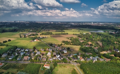
Mons is responding to the climate emergency with its Canopy Plan. Partnering with GIM, Arcea and the Belmap DT platform, the city maps vegetation and urban heat islands to guide effective greening efforts that reduce heat stress and improve urban living.
The Copernicus Global Climate Report is unequivocal: 2024 is now the hottest year on record. This sobering fact highlights how vulnerable cities are as hotspots of climate impact. Urban heat islands (UHIs) — intensified by dense development and paved surfaces — can experience temperatures up to 8 °C higher than surrounding rural areas.
With heatwaves expected to increase dramatically — from 7 days a year today to 33 by 2100 — Mons is determined to take bold, forward-looking action. Alexis Gilbart, project manager at the City of Mons, explains: “This phenomenon threatens our quality of life. We urgently need to bring nature back into our cities and make trees a central part of our climate strategy.”
Through its Energy and Climate Plan, Mons has laid the groundwork for a Canopy Plan aimed at mass tree planting. The goal is to create cool zones, improve air quality, support biodiversity and cut CO₂ emissions. Step one: conduct a baseline study to map existing vegetation and identify areas most exposed to heat island effects. “By leveraging geo-data, we can develop an iterative greening strategy that maximises impact. The analysis results will also help drive citizen engagement and support our ambitious goal of reaching 30% canopy coverage in Mons.”
Mapping and Planning
Following a public procurement procedure, GIM and Arcea were selected to carry out the study. “Their proposal aligned perfectly with our objectives,” says Alexis Gilbart. “GIM brought in a wide range of original geo-data, while Arcea contributed expertise in urban planning and environmental analysis.”
The collaboration covered every phase of the project — from assessing vegetation cover to mapping urban heat islands and identifying greening potential with concrete action plans. The final technical report includes an educational component to ensure clear communication and public involvement. “The technical strength of their proposal, plus access to Belmap DT, their Digital Twin platform, confirmed that we’d made the right choice.”

Advanced technology for accurate mapping
GIM and Arcea used a combination of orthophotos and LiDAR technology to analyse urban vegetation in three vertical layers: herbaceous, shrub and tree canopy. Orthophotos helped identify vegetation using indicators such as NDVI, while LiDAR delivered detailed vertical profiles, including tree heights and structure-based classification.
“These geo-data, combined with LoD2 building models and integrated into the Belmap DT Digital Twin platform, allowed us to pinpoint heat-prone areas with precision,” says Alexis Gilbart. The data were processed in FME to generate three strategic scores — one each for heat island exposure, biodiversity, and cost-effectiveness. “These scores help us target greening efforts where they’re most needed, in line with our broader urban strategy.”
"Moreover, with Belmap DT’s Digital Twin technology, we can run heat stress simulations based on Mons’ urban and vegetative structure," adds Alexis Gilbart.

A valuable partnership with unexpected insights
The collaboration yielded several valuable insights. “Some rural areas of Mons that appear green actually have very few trees,” says Alexis Gilbart. “Overall, canopy coverage stands at just 20%, varying significantly by area — from 5% in agricultural plains to 30% in the northeast thanks to the Bois de Ghlin. These findings are essential to designing a planting strategy that relies on strong citizen participation.”

Contact us
Your input was sent successfully.
Error
Your contact person

Mathieu Van Wambeke
+32 486 45 74 72 +32 486 45 74 72
Service Desk
Already a customer? How can we help you?
Service Desk