How many parking spaces are there in Brussels' car parks? Where is the closest public car park? And what are the differences in the parking facilities for each municipality? From now on, anyone can view the data from Parking Brussels using the interactive Map Viewer developed by GIM.
Parking Brussels, the parking agency for the Brussels Region, wants to improve mobility in the region through facilitating "smart parking". The use of digital tools plays an important role in promoting intermodality. Thanks to the Map Viewer, developed by GIM, administrations, mobility experts, design agencies, associations and citizens can get access to the most recent geographical information on parking in a few clicks. This tool is a valuable instrument for both daily operations and long-term insights. This means Brussels is taking the next step in its journey to become a Smart City where technology contributes to a better quality of life.
The challenge
Parking data and capacity utilisation are valuable information for users in search of a place to keep their car, bike or motorbike, as well as for professionals (administrations, experts, design agencies, etc.) who manage the car parks and develop the parking solutions of the future. But how can you get access to complete, accessible and up-to-date information on the parking situation in Brussels at any time?
The solution
GIM designed an interactive mapping application for Parking Brussels. This user-friendly tool displays the current parking situation in Brussels in a visually clear manner. Users can also report any errors or adjustments, thereby contributing to continual improvement of the quality of the information.
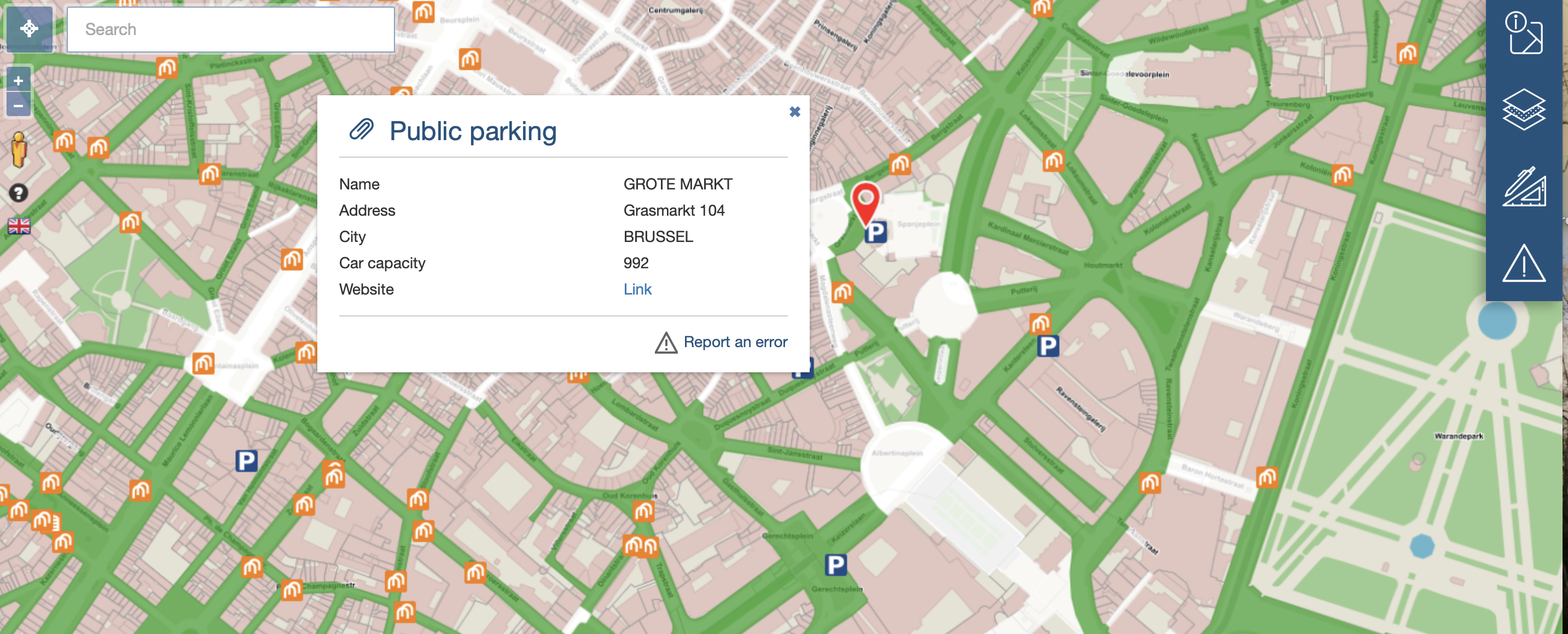
The data is updated daily and supplied via web services in accordance with open standards. Users gain access via an intuitive web mapping application based on JavaScript technology and libraries such as OpenLayers and Bootstrap. These choices guarantee a user-friendly and ergonomic interface for computers, tablets and smartphones. The application enables Parking Brussels to configure the data layers and the spatial analysis parameters themselves.
The result
The mapping application shows all public car parks and park & ride zones, as well as bike sheds and racks near a chosen location. It will show the address, opening times, rates, capacity, average capacity utilisation per timeslot, etc. Users can scroll through the map, navigate to the car park of their choice, view an image with Google Street View, report incorrect information, etc. Data and maps can be exported in various formats. Professionals, for their part, can carry out spatial analyses on the parking facilities and export their results.
To Parking Brussels' interactive Map Viewer >
Contact us
Your input was sent successfully.
Error
Your contact person

Mathieu Van Wambeke
+32 486 45 74 72 +32 486 45 74 72
Service Desk
Already a customer? How can we help you?
Service Desk