
Fibre optics is the future of broadband internet and is becoming increasingly commonplace. But rolling out fibre infrastructure is not always easy in our densely built-up country. There are many factors to consider when planning and implementing the construction of a fibre network. Fortunately, geographical data and tools provide solutions for operators and contractors. Five questions and answers from our daily practice on the role of geodata for fibre networks.
What are the socio-economic drivers for fibre network deployment?
Europe aspires to gigabit connectivity for all key economic sectors. For example, hospitals need broadband connectivity to exchange high-resolution images. But many other actors also benefit from fibre connectivity. For BIPT, we are currently carrying out an analysis of the drivers for fibre network deployment. This will allow BIPT to formulate answers to questions such as:
- Who are potential users of fibre infrastructure?
- Where are they located?
- How much capacity is needed?
Using spatial analyses based on Belmap and other data sources, our geo-experts provide BIPT with crucial insights for future infrastructure deployment.
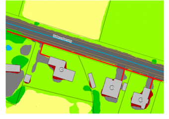
"Which are the most appropriate routes for a fibre network?"
In practice, the construction and expansion of a network collides with many obstacles, such as rivers, railways, bridges and roads. For the Roads Agency, we map the most appropriate routes for expanding their network. Based on this information, we provide insights for the evolution and dimensioning of this infrastructure.
What is the cost of digging for fibre optic networks?
Network operators and contractors want to be able to estimate the cost of building a network as accurately as possible. Excavation work accounts for a significant proportion of this. The cost of opening paved surfaces, such as footpaths and driveways, is obviously much higher than for non-paved surfaces. It is therefore crucial to know what type of soil cover is present at locations where new connections will be made. Belmap's soil coverage map allows contractors and operators to make an initial estimate of the type of paving.
How many residential units should be equipped with fibre-to-the-home connections?
Dimensioning the network, calculating the number of kilometres of cable and planning the network requires a precise calculation of the number of (potential) connections. Thanks to Belmap, GIM's 3D database of buildings and addresses, operators get a detailed view of the number of addresses, facade width and height, protection status, distance from the building line and other building characteristics. In addition, we use artificial intelligence to map existing electricity and lighting poles. These can serve as carriers, eliminating the need for costly excavations.
What is the most suitable tool for planning and managing fibre infrastructure?
Several providers offer software solutions that support the process of design, planning, construction and management. The choice depends heavily on the purpose and type of data these systems need to work with. GIM's geo-experts offer support to operators looking for the most suitable solution.
Do you also have a question about the deployment of geo-data for fibre networks and fibre-to-the-home? Let us know!

Bart Tuyteleers
Business Development Manager at GIM
bart.tuyteleers@gim.be